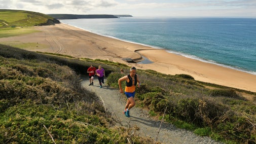
East Soar Ranger Run

This circular trail run dips and climbs along rugged cliffs where 'Dartmoor meets the sea'. A wild, partially tamed landscape with views of the Atlantic ocean, sandy beaches and farm land. Overhead raptors fly, and long-horned Highland cattle peacefully munch on the rich grassland.
Ranger Run Series
This route has been created in collaboration with expert trail runners and adventurers Jen and Sim Benson, as part of our Ranger Run Series.
Total stages: 13
Total stages: 13
Start point
East Soar car park, TQ7 3DR, SX712375
Stage 1
Turn right out of the car park and along the road.
Stage 2
Follow this quiet lane for a few hundred metres to the junction. Turn right at the T-junction, run for 100m then turn left and climb up steps onto footpath.
Stage 3
Follow the footpath across two fields, over a stone stile past the National Trust office at Southdown Farm, then left-right dog-leg by the farm road to find the public footpath and continue along the field to the green lane.
Stage 4
Turn left on Jacobs lane (green lane) and follow this to the end and the road.
Stage 5
Turn right on the quiet road down the hill to the T-junction.
Stage 6
Turn left on road then run for 75m and take the next right at the road junction.
Stage 7
Follow the quiet road for 300m and turn left on to a green lane then turn left on to a footpath then turn right before Higher Barton farm, and continue up the hill.
Stage 8
At the top of the hill turn left on the path and follow the path across the fields and then down through Hope Cove village till you hit the South West Coast Path by the sea.

Stage 9
Turn left and follow the South West Coast Path past the RNLI lifeboat station and beach. Start the climb up to Bolt Tail and onto the amazing coastal route. As you climb up from Hope Cove you will pass through the remains of an Iron Age hillfort before following the hill to the top. At the top, remember to stop at the gate and turn around to appreciate the amazing views over to Burgh Island, the Eddystone Lighthouse (18m offshore) and on clear days out to the Lizard.
Stage 10
Follow the South West Coast Path which will always be the path closest to the sea (to avoid taking a wrong turn) and appreciate the views. Halfway along the coast path you will start to drop down into Soar Mill Cove with great views and the chance to have a dip in the sea to refresh the legs for the climbs to come. A little further on the interestingly named Starehole Bottom nestles below rocky crags with many ancient hut circles and structures hidden among the banks and plants.
Stage 11
After approximately 10km pop out on the road below Overbeck's Garden. Turn left and climb the hill past the car park and the entrance, and take the footpath marked Sharpitor that runs alongside the wall of the garden.
Stage 12
Continue straight on the track over the field gate and stile. Don't turn left on the footpath.
Stage 13
Follow this path across the fields arriving back to the car park to finish.
End point
East Soar car park, TQ7 3DR, SX712375
Trail map

More near here

East Soar to Overbeck's Garden walk
A linear walk from East Soar to Overbeck's Garden. Follow the trail along the runway of what used to be RAF Bolt Head, taking in panoramic views of the South Hams coast and countryside.

East Soar to Bolt Head Walk
Explore an easy circular walk on the South West Coast Path near Salcombe, taking in the views and beaches around Bolt Head, Starehole Bay, Overbeck's and Tor Woods.

Walk to Snapes Point
Enjoy a short walk to Snapes Point, a viewpoint that offers panoramic vistas of Salcombe and the Kingsbridge Estuary.

Get in touch
You might also be interested n

Trail runs designed by our rangers
From the wild coastline of Devon to the ghostly remains of copper mines in Eryri (Snowdonia), these trail runs, designed by our rangers, will take you to some unforgettable locations.

Outdoor activities
Searching for a new outdoor activity to try? Discover the best places in our care for outdoor activities, including off-road cycle tracks, walking trails and coastlines for watersports.

Outdoor activities in Devon
Get active this winter with outdoor activities at a National Trust place near you in Devon. There's lots to do with the whole family this season.

Things to see and do at East Soar
With a variety of walks and views, East Soar has plenty to see. Discover seascapes, secret coves and rugged clifftop walks along the way. You could even try out some outdoor activities.

Staying safe at National Trust places
The special places in National Trust care sometimes come with a few risks for visitors, be it coastline or countryside. Find out how to keep safe throughout your visits.

Follow the Countryside Code
Help to look after National Trust places by observing a few simple guidelines during your visit and following the Countryside Code.

Best places for coastal running
Choose one of our favourite coastal running spots and see where it takes you – miles of coastal trails, wooded valleys and havens for nature await.

Top running routes with a view
Reward your next run with a view to remember. From coast to countryside, find a trail with some of the best scenery, views and wildlife at the places we look after.