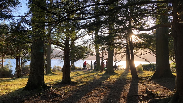
Accessible trail to Broomhill Point viewpoint
A stile-free out-and back route along the Derwent Water foreshore to the viewpoint at Broomhill Point, with views over the water to Cat Bells and Causey Pike. Choice of two routes at Strandshag bay, one with a smooth compact surface and one closer to the lake with some boulders, tree roots and muddy patches.
Cattle grid
This route includes one cattle grid. The pedestrian gate beside the cattle grid is narrow and opens one way. The gate is 39 inches (1m) wide. The narrowest gap is 35 inches (89cm).
Total steps: 10
Total steps: 10
Start point
Keswick Lakeside Car Park, Grid Ref: NY265229 what3Words ///waltzed.sideburns.cases, Postcode: CA12 5DJ
Step 1
Start from Keswick Lakeside carpark. Exit the carpark onto Lake Road past Theatre by the Lake. Continue down the tarmac for 164yds (150m) to the lake.

Step 2
At the bottom of the slope on the left, there is a map panel showing this route and others, beside the Moon and Sixpence coffee shop. Carry straight on along the road along the promenade for 273yds (250m), ignoring three entrances to the left into the woods.

Step 3
There is another downhill gradient 5% towards where the tarmac ends. Take the National Trust path and continue for 164yds (150m) until you get to the fork.

Step 4
At the fork you have a choice: You can turn right for the optional 273yds (250m) out-and-back to the famous viewpoint of Friar’s Crag. Alternatively you can turn left for the two alternative routes around Strandshag Bay (skip to step 5).

Step 5
There are two options for Strandshag Bay. The upper path is via the 4ft (1.2m) two-way gate visible immediately as you take the left fork. This path is 4ft (1.2m) wide with a smooth compacted surface, two benches, and a 16yd (15m) stretch of wooden boardwalk covered in avian wire. The upper and lower paths meet up again after 390yds (360m) on the far side of the bay beside a fallen tree. This field is grazed by sheep.

Step 6
Where the paths meet up again there is a bench – this is the last bench on this route until you get to Broomhill Point viewpoint. Go straight ahead through the gate into the woodlands over the bridge onto the boardwalk. The gate is 4ft (1.2m) and is two-way opening. The bridge is 1.5m wide the boardwalk is 2m wide with a tapping rail on both edges. Continue along the two stretches of boardwalk to the T junction

Step 7
At the end of the 2nd boardwalk, turn right and climb the gentle incline up to the main track (12% gradient). Keep right along the main track – it is sign posted to the Lake. This track is used by vehicles. There are many potholes. You’ll come to a cattle grid with a narrow pedestrian gate.

Step 8
After the cattle grid, the track slopes downhill (12% Gradient) then climbs an uphill 16% gradient. There are small boulders protruding from the surface the surface can be muddy after rain. It also turns a corner on an adverse camber. At the fork keep left away from the houses. Then the path follows the fence line at the edge of the field with views out over the lake. The path is 2m wide with a smooth compact surface with sudden muddy patches.

Step 9
At the gate, go straight through the gate. This gate is a one way opening gate that opens towards you with a pull handle. It is a 4 foot (1.2m) gate. Climb the gentle incline to the yew trees (less than 4% gradient). At the fork in the path keep straight on the path is level but has some exposed tree roots and it leads you to the semi-circular bench at Broomhill Point viewpoint.

Step 10
The most accessible route back from the viewpoint is to retrace your steps back to the car park. The route which continues from here around Calf Close Bay is badly eroded by winter storms, and includes deep muddy patches, deep shingle and gravel, tree roots and debris and a 40% gradient. You could descend to view the 100 Year Stone sculpture which is 87 yds (80m) further on from the viewpoint down a 20% gradient. The sculpture is only accessible via a shingle gravel beach and is submerged when lake levels are high. (NB Look Out For – see below)

End point
Broomhill Point viewpoint, Grid Ref: NY267215 What3Words ///wished.column.output Postcode: CA12 5DL
Trail map

Get in touch
Our partners

We’ve partnered with Cotswold Outdoor to help everyone make the most of their time outdoors in the places we care for.

Follow the Countryside Code
Help to look after National Trust places by observing a few simple guidelines during your visit and following the Countryside Code.

Things to see at Derwent Water and Keswick
Take in the views from Friar’s Crag and visit historic sculptures on a lakeside walk around Derwent Water or set off from Keswick to explore the surrounding woodlands and fells.

Wildlife in Borrowdale and Derwent Water
Discover the internationally significant ‘Atlantic oakwoods’ and Derwent Water which support a variety of rare species of plants and animals, including the red squirrel and vendace.
