Fell Foot Park Short Loop

An accessible, stile and step free circular route around the Fell Foot parkland, taking in Windermere lakeshore with views across the lake to Fairfield Horseshoe.
Steep gradients
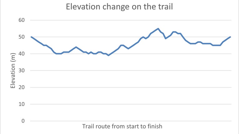
There are short and steep uphill and downhill slopes. The largest section of gradual incline is 109yd (100m) with an average gradient of 11% and a 7ft (2m) stretch at 20%.
Total stages: 13
Total stages: 13
Start point
South Car Park (Listed in the leaflet as the Meadow Car Park), Fell Foot Park, Newby Bridge, Windermere, Cumbria, LA12 8NN. Grid reference: SD 3801 8678 what3Words: thrones.laminate.presented
Stage 1
Leave the car park on the path next to the parking machine. The path has a downhill slope of 5%. Halfway along is the steepest section at 15% for 16ft (5m).

Stage 2
At the crossroads, take in the view and continue straight on the path as it continues downhill towards the lake. Here the steepest gradient is 13% for 52ft (16m).

Stage 3
Turn right at the junction and continue to the boathouse. The path surface is made up of very fine compacted gravel and the steepest uphill gradient is 4%. There are 5 metal benches along this stretch of footpath which provide great views of the lake. There is a 1m space next to the fifth bench for a wheelchair.

Stage 4
At the boathouse complex, continue straight onto the cobbles to the picnic benches.

Stage 5
To continue on this route, you must go through the café. Enter the Boathouse Café and exit through the door on the right at the counter. Here you will find a changing place and disabled toilet accessed by a radar key- one of which is available from the café. The door into this space has a width of 36in (92cm) and opens away from you.

Stage 6
Turn right and walk past the winch and leave through the door at the end of the building on the right-hand side. Go straight ahead uphill for 13yd (12m) to the path junction. The steepest gradient is 15%.

Stage 7
Take the gravel path on the immediate left going past the sign for Active Base.

Stage 8
Go straight ahead across the wooden decking to the tarmacked path to the car park machine.

Stage 9
At the car park machine turn right onto the tarmacked road. Keep left of the fork until the wooden gate on your right.

Stage 10
Turn right and go through the gate. Keep on this tarmacked path to the junction ignoring one path on the right.

Stage 11
At the fingerpost, take the path on the right which slopes downhill. The path is made up of compacted gravel material. The steepest gradient is 14%.

Stage 12
At the beech tree continue straight ahead. Ignore the path on the left and continue towards the play area.

Stage 13
Before the wooden shed on the right-hand side there is an adapted picnic bench next to the path. There are different seating options but the narrowest gap between the seats is 29in (75cm). At the wooden shed, turn left and make your way back up to the car park where you began.

End point
South Car Park (Listed in the leaflet as the Meadow Car Park), Fell Foot Park, Newby Bridge, Windermere, Cumbria, LA12 8NN. Grid reference: SD 3801 8678 what3Words: thrones.laminate.presented
Trail map

More near here

Townend and Troutbeck Valley walk
A 4-mile circular walk through classic Lake District scenery from Brockhole near Lake Windermere, through Troutbeck Valley to Townend, a 17th-century farmhouse.

Sizergh wildlife walk
Follow this route from Sizergh Castle for views of the Lakeland Fells, the Pennines and Morecambe Bay, as well as birds, butterflies, wildflowers and some unusual animals.

Holeslack Accessible Trail
Take this accessible circular route for a flavour of the Sizergh estate, from ancient woodlands and traditional Westmorland orchards to historic farm buildings and parklands.
Get in touch

Visiting the Lake District with your dog
Here's how to get the most out of a visit to the Lake District with your dog, while protecting the countryside and keeping livestock and wildlife safe.

Walking in the Lake District
From gentle ambles to more challenging hikes, these are some of the best walks to explore the heart of the Lake District.
