Kendal to Sizergh along the River Kent
Lake District
A walk from the historic heart of Kendal to the pastures of the 13th-century Sizergh estate, along the banks of the beautiful river Kent.
Near to
SizerghStart point
Kendal Market Square, grid ref: 516928, post code: LA9 4TRTrail information
Difficulty
Full trail
DistanceMiles: 5.5 (km: 8.8)Short trail
DistanceMiles: 5.5 (km: 8.8)Address
Kendal Market Square, grid ref: 516928, post code: LA9 4TR
By busIt's about a 5 minute walk from Kendal Bus Station to the Market Square start point. Turn right out of the station onto Blackhall Road and take the first right onto Stramongate. Follow Stramongate for one block, turning right onto the cobbled street of Branthwaite Brow which enters Market Place. You can also get the bus back from Sizergh to Kendal at the end of your walk.
By trainKendal Train Station is an 11 minute walk from the market square start point. From the station cross the road to the County Hotel, then turn left in front of the hotel to join Wildman Street and walk over the river. At the bridge, the same road becomes Stramongate, which you follow for two blocks, then turn right onto the cobbled street of Branthwaite Brow which enters Market Place.
On footThe Market Square start point can easily be accessed on foot from the bus station, Kendal Train Station and Oxenholme Station.
By roadThe closest cark park to the start point is the council car park by Booths supermarket, post code LA9 4DP. There is also a car park at Sizergh, in case you'd like to do the walk in reverse and catch the bus back to your car.
- Car park
There is carparking at Sizergh, and the nearest carpark to the starting point of the walk is at Booths supermarket.
- Toilet
There are toilet facilities at Abbot Hall, Low Sizergh and Sizergh.
- Café
There are three cafes on this route - at Abbot Hall gallery, Low Sizergh Farm and Sizergh.
The walk is 5.5 miles, and includes some rough country trails through farmland and woods with narrow gates. Parts of the walk alongside the river Kent have steep ground adjacent to the path, and care should be taken to stay on the path. Parts of the trail can be muddy after rain, so we recommend sturdy footwear.
Total stages: 16
Total stages: 16
Start point
Kendal Market Square, grid ref: 516928, post code: LA9 4TR
Stage 1
Start at Kendal Market Square. With the market square behind you, turn left on Stricklandgate and walk south, towards the Town Hall. Once you reach the Town Hall, cross Lowther Street and walk straight on as far as Dowker's Lane, which connects to Abbot Hall Park.
Historic yards and streets
Notice all of historic yards which you pass along the high street, and the name of the high street - 'Stricklandgate', which is derived from 30 generations of Stricklands, who founded the Sizergh estate and still live there today. Kendal’s famous 18th century yards filled up with cottages, industry and workshops to support the growth of Kendal’s trades, the most important of which was the wool trade. At it’s peak there were 150 yards, and the history of many of these yards can be enjoyed today as you walk along the High Street. Look out for the Kendal Civic Society plaques in each yard which tell you more. Collin Croft yard, adjacent to HSBC on the opposite site of the street just after Lowther Street crossing, is arguably the best preserved yard, and has many interesting features. Look out for the covered steps from Collin Croft back to the high street - you'll pass through the former sites of Collin Croft Brewery, a Malt Shovel Inn, an iron foundary, timber yard, brass foundary, printing works, stables and cottages.
Stage 2
At Dowker's Lane, turn left and enter Abbot Hall park. Walk through the park and cross the pedestrian bridge.
Abbot Hall
There's the option to take a detour at the park, and stop for coffee and culture at Abbot Hall - a gallery with a café, operated by Lakeland Arts. On the right hand side of the park there is an exit half-way which leads to the entrance to the gallery. Check the website for opening times.
Stage 3
Cross the road and turn left on Aynam Road, then immediately right onto the quiet residential Queen Katherine Street. At the top of the street join the footpath which connects you to the historic Kendal to Lancaster canal trail. Turn right along the traffic-free trail, which will take you through Kendal to the river Kent.
The Lancaster to Kendal canal
The final section of the canal linking Kendal to Lancaster opened in 1819. The canal brought prosperity to Kendal, as coal was imported for various industries housed in and around the town, and limestone and slate from local quarries were exported. Back in its heyday, the canal banks in Kendal would have been populated with wharves, stores and warehouses. The last barge load of coal was brought to Kendal in 1944, and the canal began closing in sections from 1947. Today the Towpath Trail celebrates its heritage and follows the original towpath.
Stage 4
At Park Side Road, safely cross the road and re-join the canal trail on the other side.
Stage 5
At Burton Road, safely cross the road and re-join the canal trail on the other side.
Stage 6
Where the canal trail meets Natland Road, cross the road and walk along Watercrook Lane which is a narrow country lane with very little traffic.
Stage 7
At the end of the short lane, just before the farm stead, look for a footpath finger post on the left to join the footpath and cross through farm gates to walk across a field path. In the second field the path leads down to the river Kent.
The remains of a Roman fort
On your right hand side behind Watercrook farm lie the remains of the Watercrook Roman fort. The fort was erected around AD 90, originally in timber but then rebuilt in stone around the year 130 AD during the reign of Hadrian, refurbished under Marcus Aurelius and occupied until around 270 AD, when its military units departed.
Stage 8
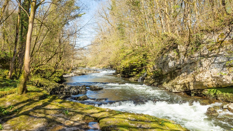
Follow the footpath alongside the river Kent and enjoy the scenery, created by one of the shortest rivers in England.
The river Kent
The river Kent is both a UK designated SSSI (Site of Specific Scientific Interest) and an EU designated SAC (Special Area of Conservation). The Clean River Kent Campaign was established in autumn 2021, and aims to make the river clean for all types of water-based recreation and to protect the ecology and wildlife in the river by working with local people. They are a volunteer coalition of communities living along the river Kent, including members from Staveley, Burneside, Kendal, Sizergh and Levens.

Heron in the River Kent at Sizergh, Cumbria | © Nicola Fearnley, Clean River Kent Campaign Stage 9
At Hawes Bridge, turn right to walk a few metres along the country lane (Hawes Lane) and re-join the footpath on the left hand side, just before the bridge, to re-join the path alongside the river Kent.
Stunning scenery and the suspension bridge
This is arguably the most scenic part of the walk, as the footpath passes through woods with lovely views of the river rapids below. You'll soon reach the suspension bridge, which turned 150 years old in 2024. It was first shown on maps in 1859 as ‘new wood bridge’. The bridge is likely to have been built to divert members of the public from walking through the gunpowder works, and to ensure that all workers could access the site at one single point for clocking in and searching.

View along the footbridge over the River Kent at Sizergh, Cumbria | © National Trust Images/Annapurna Mellor Stage 10
Cross the suspension bridge and turn right. You have now entered the site of the old gunpowder works at Sizergh, and you'll pass two cottages which used to be the office where workers would clock in. Follow the minor road and you will come to an atmospheric building clad in ivy called the Sawmill and Watch house. Turn left to walk behind the ivy clad building to reach a track at the rear.
The old gunpowder works
A special and less-visited part of the estate is the site of Sedgwick gunpowder works. Much of the northern and central parts of New Sedgwick gunpowder works still survive well and it remains one of the better preserved 19th/early 20th-century gunpowder works in northern England.

Sedgwick Gunpowder Works near Low Park Woods, Sizergh, Cumbria | © National Trust Images/James Dobson Stage 11
Turn right on the track, and look for a footpath through woods on the left hand side. Follow the footpath to a wall which marks the corner of a field.
Stage 12
At the corner of the field you will find a gate which takes you into the Low Sizergh farm trail. Turn left to follow the farm trail, which is marked with small arrows up through the farm and a camping field.
Stage 13
At the camping field follow the track around and enter the farm yard at Low Sizergh farm, an organic dairy farm. Check the website for opening hours. The farm is also home to charity Growing Well, and there is a side trail to the north of the farm yard - it loops around the six-acres of organic fruit and vegetable being grown to support the local community.
Milking time, farm shop and café
There's the chance to visit Low Sizergh's barn, café and shop, and even see the cows being milked if you're there at 3:30pm! Check the website for opening hours.
Stage 14
Leaving the farm, turn left and follow the minor road alongside the hedge (with the A591 behind). At the bend in the road, you can take a shortcut path on the right hand side through woods.
Stage 15
Rejoining the road, turn right and pass through the road tunnel beneath the A591.
Stage 16
After passing through the road tunnel, walk along the country lane and turn right at the entry point into the Sizergh estate, which is marked by a large black sign. Follow the drive up to the Visitor Centre. At the cattle grid there is an option to turn left and walk alongside the top of the historic ha-ha, then rejoin the drive and enter the car park.
The Visitor Centre
Welcome to the Sizergh! Please check our website for opening times. You can enjoy tours of the gardens and house, and a well-earned drink in the café. Hourly public buses run during the day back to Kendal from a bus stop on the A591, which is a 20 minute walk from the Visitor Centre.

Sizergh's estate, garden and house, seen from above | © James Dobson End point
Sizergh carpark, grid ref: SD498878
Trail map

Map of the route from Kendal to Sizergh along the river Kent. | © Dan Taylor

Arnside and Silverdale
A place to explore miles of coastal countryside from clifftops to woodland and wildflower meadows.

Fell Foot
Lakeshore park with stunning mountain views, Boathouse cafe, watersports hire and play area

Get in touch
Exploring the estate at Sizergh
Connect with nature in Sizergh’s woodland, wetland and farmland. Find out about the wildlife you can spot while exploring this 1,600-acre estate.


