Looking after the archaeology of the coast

In addition to our nature conservation work, National Trust staff and volunteers help preserve dozens of archaeological sites along the north Norfolk coast – from Roman fortifications to Cold War installations.
Coastal areas are particularly interesting and important archaeologically. This is partly because of the historically important role of coastal towns and settlements as centres of trade, going back to the Roman period and earlier, and because of their military significance as important points for naval and air defences.
The north Norfolk coastline is a dynamic environment that is continually reshaped by coastal erosion and deposition. This brings the potential for some archaeological finds to be lost to the sea, but at the same time it creates the intriguing possibility of new finds being revealed.
Traces of Roman Britain
After the Romans conquered Britain, forts and roads were constructed around Norfolk as the Roman army became established. Just outside Brancaster is the site of the ancient Roman fort of Branodunum. The fort, built in the 230s, later became part of the Saxon Shore fortification system.
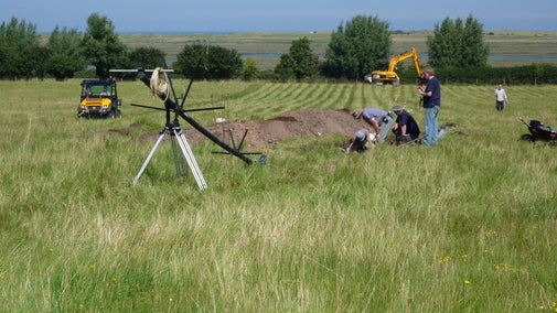
In 2012, Channel 4’s Time Team carried out a geophysical survey and excavated five trenches across the site. Several previously unknown buildings inside the fort were discovered, including huge granaries, barrack blocks for the soldiers, and a possible bath house and mansio.
At Salthouse, it is possible to find evidence of iron ore smelting dating back to the Roman times. Dark pieces of iron ore slag can be found near the beach, with small air bubbles providing the main clue that they were a by-product of the Romans’ charcoal-fired furnaces.
20th Century archaeology
The coastline is also rich in 20th Century archaeology, with many World War 2 air defences – such as pillboxes and spigot mortar bases – partially and fully intact at regular intervals along the coast.
At the edge of Stiffkey saltmarsh there is a circular concrete path, about 5m wide and surrounding an area with a diameter of 60m to 80m, known as The Whirlygig. This is the remains of a Cold War military installation. It was the site of a United States Army Air Force rotary launcher which launched Radio Controlled Aircraft Targets (RCATs) for anti-aircraft gun practice.
Look up heritage records online
You can find out more about these and other archaeological sites locally by using the National Trust’s Heritage Records Online website: heritagerecords.nationaltrust.org.uk.
This free site provides access to the National Trust’s archaeological and historic building database, a resource which holds information on over 88,000 archaeological sites and historic buildings on, or adjacent to, National Trust-owned land.
Get involved
This important record of archaeological sites is kept up to date with the help of a team of volunteers: our Heritage and Archaeology Rangers Team (HART).
Volunteers visit and explore archaeological sites cared for by the National Trust, ranging from earthworks to buildings and structures, and collect information on their condition, stability and vulnerability – information that is vital in identifying where threats may be occurring and prioritising our conservation work.
If you would like to find out more about volunteering to help with condition surveys of our archaeological sites, we would love to hear from you. Contact our Senior Volunteering and Community Officer at norfolkcoast@nationaltrust.org.uk for more information about becoming a HART volunteer.
You might also be interested in

Time Team to return to Branodunum
Time Team has announced that it will be carrying out new geophysical surveys at the site of Branodunum Roman Fort, Brancaster.

Branodunum Roman Fort
The ancient Roman fort of Branodunum, just outside Brancaster, was built in the 230s and later became part of the Saxon Shore fortification system.

Brancaster Estate and the D-Day landings
Discover the part that Brancaster Beach played in the D-Day landings that took place during the Second World War.