Discover more at Strangford Lough
Find out how to get to Strangford Lough, where to park, the things to see and do and more.

Strangford Lough and its surroundings are steeped in history dating back thousands of years. Mesolithic hunter gatherers, Vikings and Norman invaders have all left their mark here. Learn how the wealth of archaeological evidence tells a story of humankind’s dependence on the lough.
Prehistoric communities would have found rich pickings in the abundant natural resources of Strangford Lough and its foreshore. Mesolithic shell middens (piles of discarded shells) dating to 7,000 BC are evidence that our ancestors took advantage of the plentiful supply of oysters, cockles, mussels and other edible shellfish.
Burial sites like those discovered at Audleystown and Millin Bay have been dated to around 4,000 BC. These early inhabitants would have travelled around the lough using simple dug-out log boats like the one that was discovered in Greyabbey Bay.

One of the most impressive archaeological discoveries in Northern Ireland is the Neolithic log boat at Strangford Lough. Sitting in the sands at Greyabbey Bay, this amazing archaeological find was uncovered in 2000 by the Centre for Maritime Archaeology as part of a lough-wide survey.
A sample of the wood was radiocarbon-dated to between 3,499 and 3,032 BC. This makes the Neolithic log boat in Strangford Lough over 5,000 years old and the oldest boat in Ireland found in a marine setting.
It's thought that early inhabitants of Strangford Lough designed the boat as a means to catch fish for food. Perhaps tired of eating shellfish and seaweeds from the shore, they created a floating vessel by hollowing out a large tree trunk. Using only stone tools, it must have taken them weeks.
Although the sides have mostly rotted away, there is enough of the base remaining for archaeologists to calculate the shape and size of the vessel.
It is thought that this impressive discovery was 30.67 feet (9.35 metres) long, with a thick hull and low centre of gravity, which gave it stability in a choppy marine environment. The boat could probably carry up to five people and could have been used to cover quite long distances at sea.
If the boat were to be removed from the mud completely, it would probably start to rot away unless it was stored in expensive facilities and under preservative chemicals.
This is why the decision was made to leave it in the exact position it was found. By allowing it to remain in this spot for a few thousand years more, future generations can admire it in the place it was discovered.

In AD 432, St Patrick is said to have sailed through the Strangford Narrows and up the Quoile Estuary, bringing Christianity with him. By the mid-6th century a number of major monastic centres had developed in the area, including Down, Nendrum, Movilla and Bangor, as well as a number of smaller sites like Comber and Kilclief.
The monastic communities brought with them the great technological and organisational skills necessary to exploit the marine environment on a commercial scale. For example, 7th-century wooden fish traps have been found at various locations around the lough.
However, the monks of Nendrum on Mahee Island proved to be particularly sophisticated. They built a number of sea walls that trapped water at high tide. This water was then released through an opening that turned a horizontal mill wheel, which was used to grind corn. The earliest of these was dated to AD 619, making it the oldest-known tidal mill in Europe.
These wooden traps were created by driving hundreds of posts in a line into the sand. The posts were then interwoven with long slender branches. This made a barrier that allowed the water through during the falling tide – but not the fish. You can see that these traps were designed in a 'v' shape, which corralled the fish to the apex where they could easily be collected at low tide.
Larger stone traps were also used and positioned using similar principles. Large boulders were built on top of each other, with a core of smaller stones filling the gaps in much the same way as a dry-stone wall is constructed. They reached a height of over 1 metre.
A wide range of fish would have been trapped, including mullet, plaice, sea trout, mackerel and herring. The monks of Greyabbey are credited with being the main builders of these traps, as it would have taken a great degree of labour and organisation to construct, maintain and operate them.
The amount of fish caught would have been more than enough to feed the monks themselves. It's thought that much of the fish would have been dried or smoked and then sold. It really was fishing on an industrial scale.
Today, all that remains of these fish traps are lines of stones, only one or two courses high. Many were partially dismantled so the stones could be used to make kelp grids. The best place to see them is along the Portaferry Road on Strangford Lough, where it's easy to walk out across the sand at low tide. Once you know what you're looking for, you realise just how many there are.
Between the 9th and 11th centuries, Vikings were regular visitors to the lough, giving it the Norse name 'Strangfyorthe', meaning 'the place of strong currents' or 'strong fjord'.
The Vikings were no doubt attracted to the area by the promise of rich plunder at the various monastic sites. However, they were not always a warring people, and there is evidence to suggest that many traded peacefully and even settled locally.

In 1177, John de Courcy and his Norman knights invaded Downpatrick. The surrounding region was brought under Norman control by building a number of fortified mottes and they founded the Cistercian monasteries of Inch Abbey (AD 1180) and Grey Abbey (AD 1193).
The monks of Greyabbey took the building of fish traps to a whole new level, replacing the wooden traps with stone structures, sometimes more than 220 yards (200 metres) long.
With the decline of English power in the 14th century, the southern part of the lough became an isolated area under English control. However, it was still of great commercial and strategic importance and this led to the construction of a number of tower houses.
Many of these can still be seen today, including the 15th-century castles at Kilclief, Audley’s and Sketrick, and the 16th-century castles of Strangford, Castle Ward, Portaferry, Quoile and Mahee.
By the 18th century, the towns and quays around Strangford Lough were busy places, with goods being imported and exported around the world. Boat building and fishing were important local industries, as was the production of 'kelp' (the name given to the burned ashes of seaweed).
Today, there are still a great many clues to the scale and importance of the kelp industry in the form of kelp grids, kelp kilns and kelp houses. See if you can spot them on your next visit.
Seaweed only grows on a hard surface, therefore large, sandy bays would not have been very good for growing seaweed. However, some 18th-century entrepreneurs found that if they collected stone boulders from the rocky shore and placed them on areas of sand, they could create the perfect conditions to 'farm' seaweed.
These boulders tended to be placed in regularly spaced lines, forming what have become known as kelp grids. Sometimes it takes a while to recognise these – you can find good examples in Greyabbey Bay, near the shores of South Island or between Mid and Chapel Islands. At low tide, you can even spot one from the road on the northern side of Kircubbin.
The seaweed would have been cut about once every three years, leaving part of the plant still attached to ensure its regrowth. After spreading it on the fields to dry, it would have been gathered into a simple stone pit to burn. The remains of some of these kelp kilns can still be seen on many of Strangford’s islands. South and Chapel Islands have good examples.
Once the kelp cooled, it was extracted from the kilns and stored until a large enough quantity was amassed to make it worth selling. Simple stone structures known as kelp houses were built to keep the kelp safe and dry. Over the years, most of these kelp houses have disappeared as their stones were likely used for other purposes.
However, on some of Strangford Lough’s islands, these kelp houses have remained quite intact. Examples can be seen on Darragh Island and Boretree Island. As you drive along Portaferry Road, look out for the occasional line of large boulders which would have marked the boundaries between the kelp industry areas.

Find out how to get to Strangford Lough, where to park, the things to see and do and more.
Explore the largest sea lough in the British Isles, home to a variety of rare wildlife. Head out for walk, discover the local towns and villages and soak up dramatic views.

Discover the volunteering opportunities available at Strangford Lough, and how you can get involved.

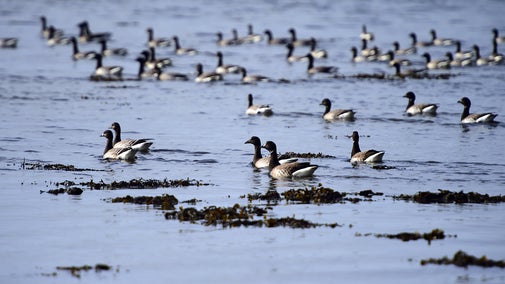
Strangford Lough is one of only three Marine Nature Reserves in the UK and home to a huge variety of wildlife. Here’s what to look out for and where to explore on your next visit.

Explore the largest sea lough in the British Isles, home to a variety of rare wildlife. Head out for walk, discover the local towns and villages and soak up dramatic views.

Learn about people from the past, discover remarkable works of art and brush up on your knowledge of architecture and gardens.
